
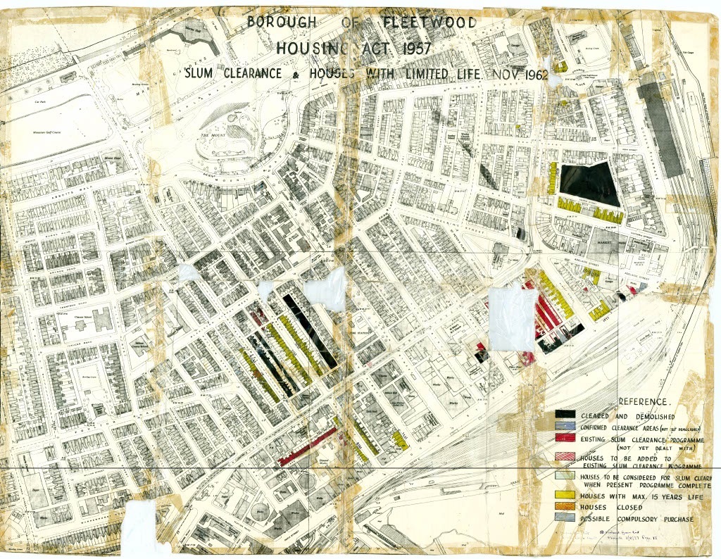
This plan was produced and amended by staff at the former Fleetwood Borough Council. The original map and its annotations date from 1962 with subsequent additions made in pen in the late 1970’s.
The title of the plan is ‘Borough of Fleetwood, House Act 1957, Slum Clearance and Houses with Limited Life Nov 1962’
The references in the bottom right indicate which houses had at that point been cleared and which were planned for demolition.
It also indicates which houses had been assessed for quality and therefore determined to be a ‘house with a max 15 years life’
The plan whilst showing signs of its age and wear and tear still highlights some interesting points:
The black indicates the houses that had already been cleared, most of those appear to have been around Elizabeth Street and close to Fleetwood Market.
The yellow also indicates those houses with a limited life span, and subsequently cleared.
The reference also shows hand written in pen, a cross, and states ‘removed from list 3/8/77”, on the plan the cross is shown in a yellow box. These were cottages around Mount Street and Walmsley Street earmarked for clearance but saved in the late 1970’s and still stand today. The cottages along Mount Street are now recognised as Buildings of Special Architectural and Historic Interest and built around 1836. They are designated as Grade II with Historic England.
On the plan where Asda is today you can see something which refers to ‘Disused Works’ with 2 gasometers. This was the former Gasworks (North West Gas Board) but as the plan indicates. disused by 1962
The plan also shows the cinemas on Lord Street, particularly The Regent and former pubs such as The Crown Hotel and Royal Hotel on Dock Street.
You can also see the former Fleetwood Railway Station and the many extensive train lines indicating the significance of the railway for the movement of good and people to and from Fleetwood.